
Our Science
The Arizona Remote Sensing Center (ARSC) was established in 1972 and since its inception, ARSC has worked on a wide range of international, national, regional, and local projects. These involve advanced airborne and satellite remote sensing data and other geospatial information technologies to help address both fundamental and applied issues in natural resource management. ARSC’s mission is to employ remote sensing and geospatial technologies to solve natural, agricultural, and cultural resource problems in the arid and semi-arid regions of the world. This mission involves both basic and applied research in support of the operational application of geospatial technologies and their extension to stakeholders, the integration of field and remote sensing data and analysis, modeling of coupled human and natural systems, and the deployment of decision support systems.
The primary activities of the center focus on research supported by research contracts and grants to develop and apply remote sensing and GIS technologies to problems in agriculture, natural resource management, and the environment. ARSC develops and maintains a number of scientific websites in response to a large demand for information and data and the need to integrate computer technology into decision support. ARSC is also dedicated to providing graduate and undergraduate students with the opportunity to acquire new knowledge and skills in remote sensing and geospatial analysis. ARSC research projects are staffed by students from a variety of campus Departments including: the Arid Lands Resource Sciences Ph.D. Program, Electrical and Computer Engineering , the School of Geography and Development, Geosciences, Hydrology and Water Resources, Management Information Systems, as well as the School of Natural Resources and the Environment .
For more information contact:
Willem J.D. van Leeuwen, Ph.D.
Director Arizona Remote Sensing Center
Environment and Natural Resources 2
1064 East Lowell Street
Tucson, AZ 85721
520-626-0058
leeuw@arizona.edu
Recent Highlights
Image

Is 60 years of revegetation sufficient to restore a mining-altered environment?
To address this question, we examined one of the few Cu–Mo tailings ponds in the U.S. Southwest that has been successfully revegetated for several decades. By integrating field-based plant and soil surveys with remote sensing analyses, we identified areas representing different stages of ecosystem recovery and a distinct pattern of plant metal(loid) uptake.
Using X-ray fluorescence to analyze conspecific herbarium specimens from natural, uncontaminated sites, we established new elemental benchmarks and evaluated whether these species exhibit constitutive metal(loid) accumulation.
Our findings provide insights that may inform reclamation planning, assist in selecting species for revegetation, and advance future research on phytomining in arid environments.
Wlodarczyk et al. 2025. Science of The Total Environment https://doi.org/10.1016/j.scitotenv.2025.180705
Image
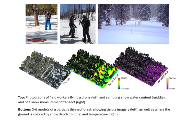
Forest Patch Geometry and Climate Regulate the Impact of Forest Thinning on Snowpack in the Southwest United States
Since 2017, we been monitoring snowpack for the Salt River Project, a water and power utility that serves millions of people in the Phoenix area to improve forecasts of how much water will be available from winter snow. Recently, we’ve been studying how forest thinning—which is commonly used in northern Arizona to reduce wildfire risk and improve forest health—affects snowpack in northern Arizona. To do this, we used a detailed snow model at one-meter resolution, supported by extensive field surveys and drone flights that measured snow depth, forest structure, and surface temperatures. We found that forest thinning generally allows more snow to reach the ground instead of getting caught in the tree canopy and lost to the atmosphere, which increases overall snowmelt. But not all thinning strategies work the same way. Approaches that create openings while still providing shade—such as long, east–west oriented gaps—tend to produce more concentrated snowmelt and keep snow on the ground longer. This pattern is especially valuable for maximizing water supply and potentially reducing vegetation stress during the dry period between snowmelt and the start of the summer monsoon season.
Broxton, P. et al. 2025. Ecohydrology https://doi.org/10.1002/eco.70111.
Image
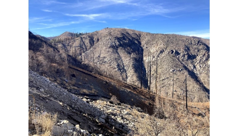
Quantifying Forest Structural and Functional Responses to Fire Severity Using Multi-Source Remotely Sensed Data
After the 2020 Bighorn Fire in Arizona’s Santa Catalina Mountains, we studied how the forest is recovering using satellite images and airplane-based laser mapping. We found that grasslands and open areas greened up faster than dense forests, which lost more trees and regrew slowly. The land often looked green again before the forest structure was truly rebuilt, showing that both vegetation greenness and forest structure must be tracked to understand recovery and plan for future wildfire resilience.
Lee, K. et al. 2025. Geographies. https://doi.org/10.3390/geographies5030030
Image
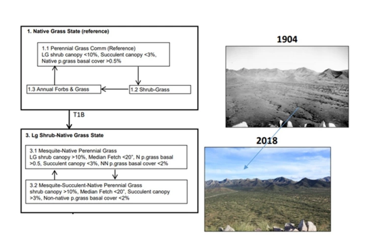
Using Fine Resolution Remotely Sensed Data-Derived Land Cover to Inform Dryland State and Transition Models
Natural Resource Managers often use state and transition models (STMs) to organize and communicate ecological information. It is often used to understand the condition of lands managed. STM vegetative states (an important component) are developed using field assessments. We wanted to repeat one such field assessment completed on the Santa Rita Experimental Range (SRER) using high-resolution (1 m) hyperspectral imagery. We found that our analysis revealed areas that were actually of another ecostate, areas that were classified differently or missed in the field mapping. High resolution, remote sensing provided a more comprehensive assessment. This type of analysis would be extremely helpful to natural resource managers determining the state of lands managed and the states lands are transitioning into.
van der Leeuw, E. et al. 2024. Rangeland Ecology & Management https://doi.org/10.1016/j.rama.2024.06.003
Image

How three-dimensional forest structure regulates the amount and timing of snowmelt across a climatic gradient of snow persistence.
Here we examine how three-dimensional (3-D) forest structure regulates snow accumulation, sublimation, and melt timing across a climatic gradient of ephemeral to seasonal snowpacks in Arizona’s headwaters of the Salt-Verde River Basin. Using multi-year Snowtography snow-depth observations, airborne LiDAR, and the high-resolution SnowPALM model, the study reveals that canopy cover reduces total snowpack through interception and sublimation, advancing melt at warmer sites but delaying it at colder, higher-elevation sites. Within canopy gaps, shaded cool edges accumulate the most snow, whereas sunny warm edges, despite lower snow depth, produce higher liquid water input (LWI) because rapid melt reduces sublimation exposure. Consequently, peak snow water equivalent (SWE) is not a reliable proxy for meltwater yield in ephemeral snowpacks. The findings emphasize that forest management can shift both the magnitude and timing of snowmelt, with trade-offs between delaying melt for forest resilience versus enhancing meltwater delivery for downstream water resources.
Dwivedi R, (2024). Front. Water. 6:1374961. doi: 10.3389/frwa.2024.1374961